
TABLE OF CONTENTS :
|
A Minimally Invasive Plan to Extend the Expo Line Eastward by Damian Gatto Introduction From Union Station to Santa Monica in an hour--and without having to drive. The westward extension of the Expo Line in 2016 was a novelty for the citizens and railfans of Los Angeles who, for the first time in six decades, had a stress-free option for making excursions to Downtown Santa Monica and the beach. When I discuss the history of rail in Los Angeles, I am quick to point out that this city once had the most expansive rail system in the world. In fact, many of the modern light rail installations--namely the Expo Line and the Gold Line--are built upon former rights-of-way where Pacific Electric Red Car and Yellow Car trolleys had once run. This is good for the purposes of avoiding the need for eminent domain and mass displacement, but it is also a poignant reminder of Los Angeles County's indecisiveness when it comes to transit options. In the second place, there has been a tendency to concentrate of the County's new rail projects in one place--namely, in Central Los Angeles. With the construction of the eastward extension of the Gold Line underway, this post examines the possibility of expanding the Expo Line southeastward from the USC area into the east side of South Central. Hypothetically, this extension could be straightforward and minimally invasive, since the track can be laid over existing rights-of-way dating from the early 20th century, the land of which has remained essentially undeveloped. These circumstances were precicely what enabled the (relatively) easy installation of the northern portion of the Gold Line, as well as the first installation of the Expo Line. Furthermore, the southeastern districts of Los Angeles, now commonly referred to as “Historic South Central” (and by others as the Pueblos or the Low-Bottoms), could benefit economically and socially from an Eastward extension of the Expo Line. Critically, such an extension could be made with little to no displacement of residents of residents or businesses. i. Exposition Boulevard, Marmion Way, and the Reuse of Historic Right-of-Ways I remember Marmion Way before the Gold Line was built. It was a pair of one-way streets running alongside dusty, old train tracks inundated with weeds and dirt. These tracks dated from the days of the old Pacific-Electric Red and Yellow Car systems; while the trolleys themselves effectively ceased operation by 1956, many of the old tracks were left in their places, if not paved right over with asphalt. The same was the case with the tracks lining Exposition Boulevard, alongside which the Expo Line now travels. Exposition Boulevard is an east-west arterial thoroughfare running from National Boulevard (near Culver City) all the way to Hope Street, just east of the USC campus. Presently, at the eastern terminus of Exposition Boulevard, the Expo Line curves northward, traveling alongside the 110 all the way to Union Station. Exposition Boulevard, meanwhile, comes to an end at Hope Street. At the intersection of Exposition and Hope, there is a gated empty lot presently used as event space. This unsuspecting lot actually marks the beginning of a series of railroad spurs that once led from this intersection all the way eastward to the City of Vernon.
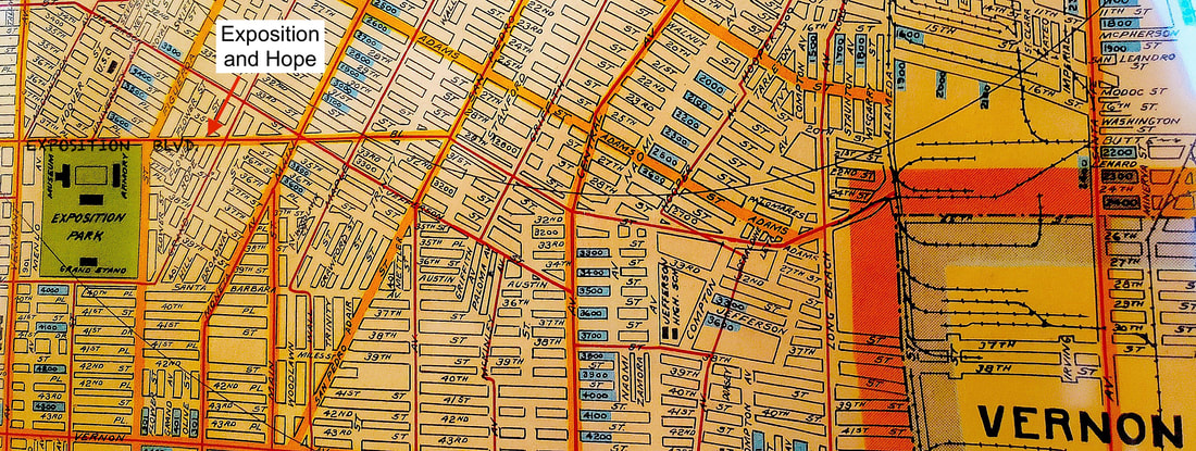 Above: A detail of Bridwell's Survey (1922) annotated to highlight the intersection of Exposition Boulevard and Hope Street and the beginning of a series of rights-of-way leading from said intersection all the way to the City of Vernon. The rights-of-way are in the center of the snapshot and form a spoon shape. ii. Obstacles in the Proposed Path This surviving segment of railway runs from Hope Street to Alameda Street, transversing other arterial streets like Main Street, Central Avenue, Maple Street, and San Pedro Street along the way. Since the demise of the Red and Yellow Cars, these spurs have officially and unofficially been converted to parking lots or used as event spaces. Otherwise, the parcels have remained vacant land, owned either privately or by the government. 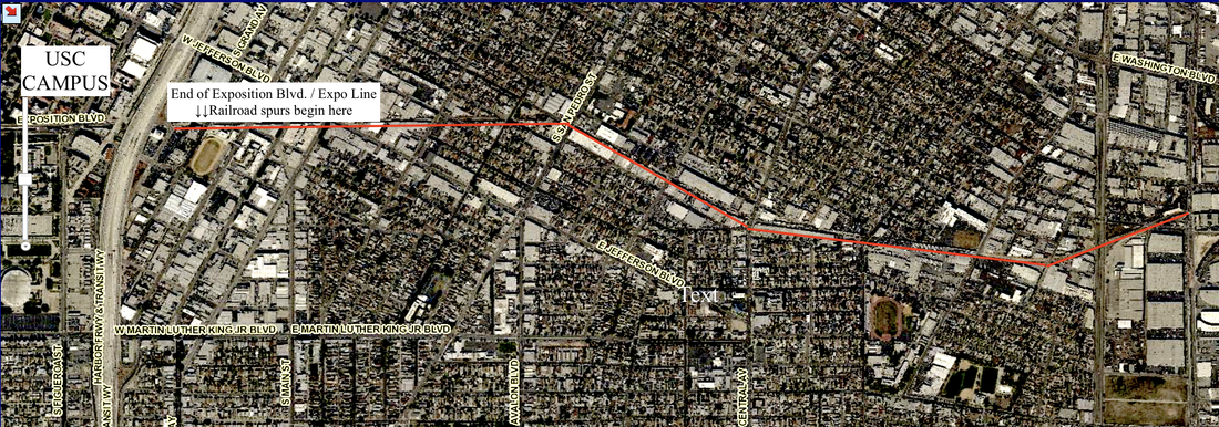 Currently, there are a few obvious obstacles to converting these old railroad spurs back to their original usage, the first being the private ownership of some of the lots. A small number of lots were seized by the County to construct the Expo Line. I am not a fan of eminent domain, and so I cannot advocate that as an option. However, if the County were to pursue the option of eminent domain, it would not necessarily preempt the lots' current uses as parking lots. I elaborate more upon this below (see Part 3 of this article). Below are diagrams of the land uses along the proposed path of the extension. CLICK "READ MORE" BELOW
3 Comments
The Entirely Readable City: Notes on Los Angeles Cartography and Street Grid (s) by Damian Gatto  Source: Google Maps Whenever I tell people I studied urban planning and that I am passionate about effecting change in my home city, they usually politely smile and the conversation moves onward. If the conversation continues, I hear all of the (false) platitudes about LA’s urban design: how it consists of mindless, unplanned sprawl (false), or how it lacks a coherent address system (false), or how it lacks a perfect, contiguous waffle grid (okay, true), among other things. Author David C. Sloane does a great job disproving the characterization of LA’s sprawling nature as “mindless” throughout his brilliant book Planning Los Angeles. However, there remains the widespread idea that LA’s present state of design owes its design to poor planning processes. Recently, Christopher Hawthorne of the Los Angeles Times described a Los Angeles that is "hard-to-read. " While I can appreciate Hawthorne's extended anecdotes about growing up in a city he couldn't predict, and how all these other random irrelevant people have described Los Angeles' urban form as an "improvisation," I must objectively disagree with Hawthorne's interpretation of Los Angeles' urban landscape and street grid. ========================================================================== In response, this column is about the urban design of Los Angeles— specifically, the evolution of Los Angeles’ street grid and address system. ========================================================================== The fact is that Los Angeles’ street layout and address system is a product of the City’s evolution, numerous annexations, and the region's natural topography. During its first epoch--from 1781 to 1850-- Los Angeles was a humble pueblo, lacking any big plans for the future. The pueblo's boundaries and its street grid were a fraction of their current size. Beginning about two decades following California statehood, LA’s street layout was further altered as a result of various annexations, most of which occurred between the 1880s and 1930s, resulting in the distinct “clashing grid” that characterizes the City's urban design. Finally, there were erasures and re-drawings of small sections of the City throughout the 20th and early 21st centuries. Furthermore, the end of this article, there will be mention of how the Los Angeles region’s natural topography shaped the city’s urban design and layout. CLICK "READ MORE" BELOW
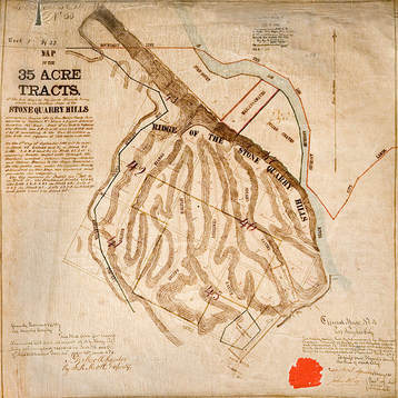
The Lasso of La Loma: A Genealogy of the Few Remaining Chavez Ravine Streets by Damian Gatto Chavez Ravine is the historic name for the hillside immediately northeast of Los Angeles’ Chinatown, and for the communities that once existed in these hills. For many, this land still is--and always will be--Chavez Ravine, the Lil' Town. I. The Lil’ Town City Councilman and namesake Julian Chavez acquired the land that would become Chavez Ravine, along with much of the land that would become Elysian Park, in the 1840s. The Stone Quarry Hills, as they were known then, was already populated with several ravine enclaves. By the late-19th/early-20th Century, “Chavez Ravine” was defined by four neighborhoods: Palo Verde, Bishop, La Loma, and Solano Canyon. Disdained as worthless land, and seen as too remote to make residential development pragmatic, it was initially the site of, among other things, a blasting mine. In 1926, LA City Council voted to zone Chavez Ravine for exclusively residential use.
Sadly, most people know about Chavez Ravine because of the way in which it met its demise, rather than its fascinating, unique, and diverse history. Originally, the communities of Chavez Ravine were razed through the power of eminent domain (the interpreted constitutional power of the government to seize land with "just" compensation) to make way for public housing designed by Richard Neutra. As the story goes, because of the anti-Communist political atmosphere of the time, this proposed “socialist” form of land use fell from favor. Following the infamous "helicopter ride," the land was purchased by the Dodgers, the final families were violently evicted, and Dodger Stadium was constructed in the early 1960s. Fewer than a dozen families remained by that time, most notably the Arechiga and Perich families, who were infamously documented being physically dragged from their home by LA County Sheriffs as news cameras rolled. Once a contiguous range of ridges, the construction of the Stadium and its giant parking lot were made possible by leveling the ridge lining the Bishop and Palo Verde neighborhoods and infilling the remaining gap with silt. Angelenos formed communities in Chavez Ravine for a century before Dodger Stadium came around. A truly sui generis community, its humble, owner-built bungalows and country markets contrasted with the bustle of Downtown, less than one linear mile away. A mostly Latino community by the early 20th century, it also had a considerable number of Slavic, Italian, Jewish, German, and Anglo residents. A remarkable mixture of people, mostly working class, flocked there not only to live the simpler life, but also to avoid housing discrimination in other sections of the City. Residents built their own homes and raised livestock. Children frolicked in its dirt roads. People looked out for each other. This idyllic, agrarian setting was almost too good to last forever in the rapidly modernizing City of Angels. II. The Physical Remains of Chavez Ravine When Dodger Stadium was built, only the Solano Canyon community was spared in its entirety. However, terraced above the 110 Freeway, south of the Stadium, are also the few remaining traces of the La Loma neighborhood: six streets from the neighborhood, lined with foundations of houses and-- if you look hard enough-- scattered belongings. Take the Academy Road exit off of the southbound 110 Freeway. Traveling northbound, Solano Avenue terminates at Bouett Street. Bouett, in turn, dead ends at a City-padlocked gate. Beyond this gate is Brooks Avenue, which travels southward up into the hills and merges with Spruce Street, coming to an end at the ovular Aqua Pura Drive. The arrangement forms a neat little lasso shape on a map. Below is a detail of Baist's survey (1910 and 1921), depicting the respective lot cuts and all. 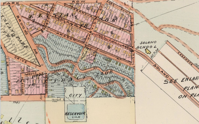 Above: Enlarged detail of the 1921 Baist survey depicting the lot cuts on our five sample streets: Bouetts, Brooks, Spruce, Aqua Pura, and Pheonix. Yolo Drive is also pictured. (Source: USC Digital Libraries) Immediately west of this lasso-shaped island, leading to the Chavez Ravine Reservoir, is a tiny stub of what used to be Yolo Drive. Parallel to Spruce Street (and right behind the San Conrado Church) was the serpentine Phoenix Street. Although Phoenix Street was formally designated, it was never paved, and as such has receded from view. At present, it is slowly being reclaimed by nature. You can hike up into the hills behind the church, along Phoenix Street, up until where it intersects with an old, unpaved portion of Jarvis Street. Here is where you will find poignant signs of former habitation, such as foundations of houses. You can see items that had just been in the kitchen…or in the family room…or on the porch… one day, 60-odd years ago. It is truly profound. It feels wrong to remove or even touch these things. III. A Genealogy of The Neighborhood Bouett Street, Brooks Avenue, Spruce Street, Aqua Pura Drive, and Pheonix Street. With this sample size--five streets, sans the stub of Yolo Drive, for now-- I decided to conduct a street genealogy in order to deduce the demography as well as some of the building habits of La Loma folks, to see if I could paint a picture of the geography of a Chavez Ravine neighborhood. Though it would be quite an undertaking to perform such a task for the entirety of Chavez Ravine, someday I may do just this. The following is a list of all the recorded house numbers on these streets, containing the names and families appearing on the original titles of the properties, their mailing addresses (if applicable), and whether they built the structure(s) themselves or hired a contractor-builder. If an original title was not available to deduce the name of the owner-builders, the names of the earliest known owners are listed instead. + Phoenix Street’s address system ran from 600 to 800. + Aqua Pura Drive’s address system ran from 600 to 700. + Spruce Drive’s address system ran from 500 to 800. + Brooks Avenue's address system ran from 1700 to 1900, and from 700 to 900. Much of the 1800 to 1900 block of Brooks (save for 1860) is still standing today, and as such is omitted below…for now. + Bouett Street's built environment still largely stands, and so a street genealogy is omitted...for now. CLICK "READ MORE" BELOW
THE NATURE BOYS OF EDENDALE The Spiritualists, the Colburn Institute, the Landacres, and the Destruction of Urban Forests by Damian Gatto Originally published 24 April 2014 and updated mid-2017 INTRODUCTION In a city that is so built-up and is always trying to reinvent itself, it can be hard to recognize or appreciate the humble origins of many of its neighborhoods. At the turn of the 20th century, Edendale was something of a pastoral scene. As you stand at the northern terminus of Alvarado Street, looking north, you can almost see it. The Pacific Electric Red Car ran roughly where the 2 is. The hills of Silver Lake, Echo Park had only begun to exhibit little wooden bungalows. The Mediterranean landscape was mostly unspoiled by industry or development. The open roads were lined not with graffiti- covered soundwalls, but instead with Cedars and Live Oaks. 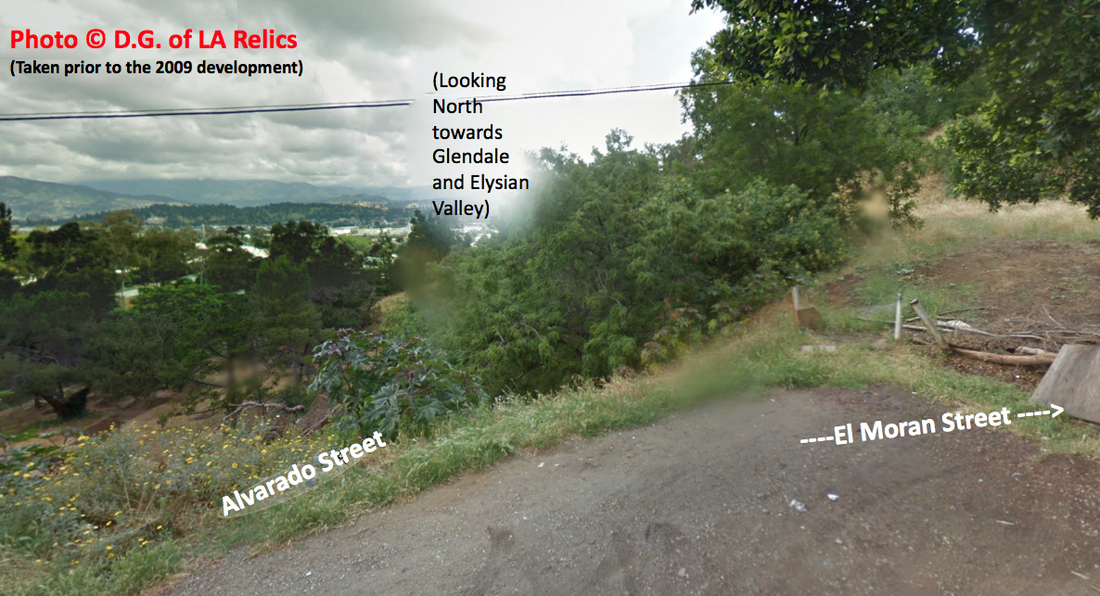 Above: A panorama taken by me of the Spiritualist Tract in 2009, before the Via Artis Development ravaged the whole hillside meadow. Below: The same vantage in the early 1900s. Notice the trolley tracks laid out. 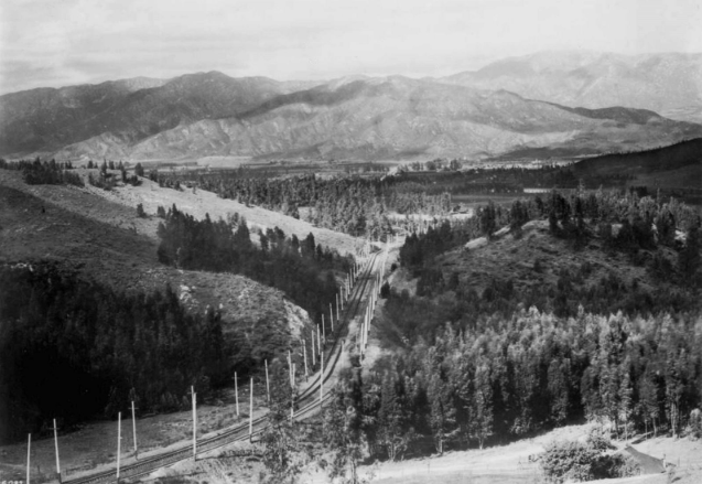 Los Angeles' most prolific period of growth occurred between 1880 to 1930. Neighborhoods like Lincoln Heights and Highland Park, just a few miles from Downtown, became some of the first “suburbs” of Los Angeles. As Los Angeles' population exploded by 10,970% during this five-decade period, there were Angelenos who sought to escape from this modernization and immense growth. While many came to Los Angeles for symptomatic relief from respiratory illness and flee the machine politics and density of the East Coast, others came to reside in the pseudo-agrarian landscape on the outskirts of the City.
This article is about the the Nature Boys of Edendale: the Semi-Tropic Spiritualists, the Colburn Institute, and the Landacres......and the destruction of their urban paradise. CLICK "READ MORE" BELOW |
Archives
December 2022
Categories
All
|

 RSS Feed
