
TABLE OF CONTENTS :
|
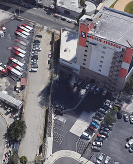
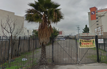
A Minimally Invasive Plan to Extend the Expo Line Eastward by Damian Gatto Introduction From Union Station to Santa Monica in an hour--and without having to drive. The westward extension of the Expo Line in 2016 was a novelty for the citizens and railfans of Los Angeles who, for the first time in six decades, had a stress-free option for making excursions to Downtown Santa Monica and the beach. When I discuss the history of rail in Los Angeles, I am quick to point out that this city once had the most expansive rail system in the world. In fact, many of the modern light rail installations--namely the Expo Line and the Gold Line--are built upon former rights-of-way where Pacific Electric Red Car and Yellow Car trolleys had once run. This is good for the purposes of avoiding the need for eminent domain and mass displacement, but it is also a poignant reminder of Los Angeles County's indecisiveness when it comes to transit options. In the second place, there has been a tendency to concentrate of the County's new rail projects in one place--namely, in Central Los Angeles. With the construction of the eastward extension of the Gold Line underway, this post examines the possibility of expanding the Expo Line southeastward from the USC area into the east side of South Central. Hypothetically, this extension could be straightforward and minimally invasive, since the track can be laid over existing rights-of-way dating from the early 20th century, the land of which has remained essentially undeveloped. These circumstances were precicely what enabled the (relatively) easy installation of the northern portion of the Gold Line, as well as the first installation of the Expo Line. Furthermore, the southeastern districts of Los Angeles, now commonly referred to as “Historic South Central” (and by others as the Pueblos or the Low-Bottoms), could benefit economically and socially from an Eastward extension of the Expo Line. Critically, such an extension could be made with little to no displacement of residents of residents or businesses. i. Exposition Boulevard, Marmion Way, and the Reuse of Historic Right-of-Ways I remember Marmion Way before the Gold Line was built. It was a pair of one-way streets running alongside dusty, old train tracks inundated with weeds and dirt. These tracks dated from the days of the old Pacific-Electric Red and Yellow Car systems; while the trolleys themselves effectively ceased operation by 1956, many of the old tracks were left in their places, if not paved right over with asphalt. The same was the case with the tracks lining Exposition Boulevard, alongside which the Expo Line now travels. Exposition Boulevard is an east-west arterial thoroughfare running from National Boulevard (near Culver City) all the way to Hope Street, just east of the USC campus. Presently, at the eastern terminus of Exposition Boulevard, the Expo Line curves northward, traveling alongside the 110 all the way to Union Station. Exposition Boulevard, meanwhile, comes to an end at Hope Street. At the intersection of Exposition and Hope, there is a gated empty lot presently used as event space. This unsuspecting lot actually marks the beginning of a series of railroad spurs that once led from this intersection all the way eastward to the City of Vernon.
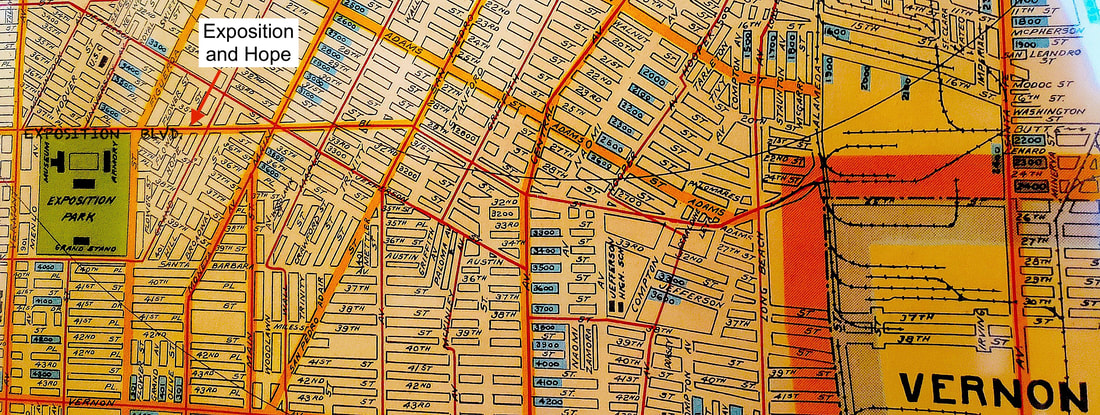 Above: A detail of Bridwell's Survey (1922) annotated to highlight the intersection of Exposition Boulevard and Hope Street and the beginning of a series of rights-of-way leading from said intersection all the way to the City of Vernon. The rights-of-way are in the center of the snapshot and form a spoon shape. ii. Obstacles in the Proposed Path This surviving segment of railway runs from Hope Street to Alameda Street, transversing other arterial streets like Main Street, Central Avenue, Maple Street, and San Pedro Street along the way. Since the demise of the Red and Yellow Cars, these spurs have officially and unofficially been converted to parking lots or used as event spaces. Otherwise, the parcels have remained vacant land, owned either privately or by the government. 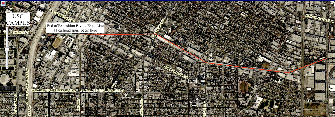 Currently, there are a few obvious obstacles to converting these old railroad spurs back to their original usage, the first being the private ownership of some of the lots. A small number of lots were seized by the County to construct the Expo Line. I am not a fan of eminent domain, and so I cannot advocate that as an option. However, if the County were to pursue the option of eminent domain, it would not necessarily preempt the lots' current uses as parking lots. I elaborate more upon this below (see Part 3 of this article). Below are diagrams of the land uses along the proposed path of the extension. CLICK "READ MORE" BELOW
3 Comments
|
Archives
December 2022
Categories
All
|
 RSS Feed
