
TABLE OF CONTENTS :
|
ENTER THRU THE REAR: A History of Alleys in Los Angeles and Around the World... ...And How to Repurpose Them! by Damian Gatto 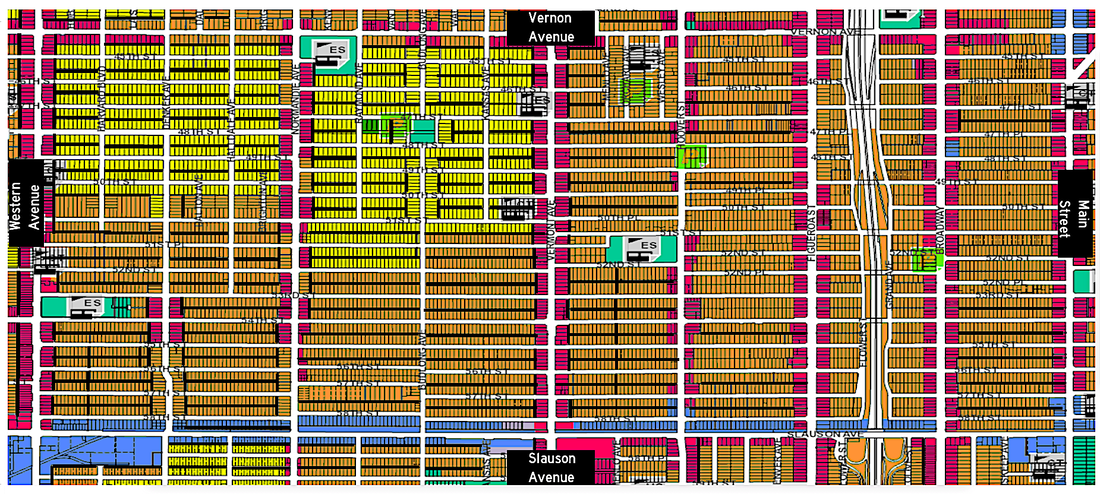 Since the early 20th century, urban alleyways in North America have conjured imagery of abandonment, clandestinity, and hazard. However, for thousands of years across human history alleys have served numerous utilitarian functions, and still do in many places around the world. Inasmuch as Los Angeles has developed a reputation as the great “unplanned city”, many districts of the city in fact have a fairly consistent gridiron layout and coherent address numbering system—complimented by an extensive network of alleys. In the United States, alleys were designed mostly for public works purposes such as utility readings, waste collection, as well as large deliveries. While alleys across the United States fell from use after the mid-20th century, so too have scholars and other thinkers mused about the possibilities for their adaptive reuse. This article will, first, provide, first, a brief history of alleyways around the world, as well as their decline and obsolescence in the United States; second, some ecological considerations; and finally, some proposed methods for the adaptive reuse of alleyways. This article will demonstrate how alleys have potential for renewed utilitarian and recreational uses. CLICK "READ MORE" BELOW I. Origins and Analogs of Alleyways a. Around the World Alley networks have been inlaid into urban street systems for at least three-thousand years. The etymology of “alley” is uncertain, with proposed origins in Old English “alee” (“a walkway”) which in turn is derived from the Latin infinitive verb “ambulare” (“to walk”). It is also hard to pinpoint the time in which “alleys,” as we know them, were invented, due to the various analogs that have arisen throughout history. Ancient Greek cities demonstrate clear distinctions in scale amongst wider “streets” and narrower “alleys”. The Spanish bastides of the Medieval era demonstrate similar distinctions between main roads and backroads. Ancient Greek cities demonstrate clear distinctions in scale amongst wider “streets” and narrower “alleys”. The Spanish bastides of the Medieval era demonstrate similar distinctions between main roads and backroads. Additionally, during the Zhou (1046-771 B.C.) and Yuan (1271-1368 A.D.) Dynasties, emperors planned cities and neighborhoods according to class hierarchy. Neighborhoods in northern China during this period, called Hutong (胡同), were comprised of narrow walkway networks serving courtyard-style row housing. Another interesting analog of alleys appear in Tokyo and other Japanese cities. Networks of urban backstreets, called yokocho (“horizontals”), are shopping and dining routes dedicated, usually exclusively, to pedestrian travel. Below: One of the few remaining Hutong of Beijing. Note the hierarchy of the built environment. (Source: shutterstock.com; sulwhasoo.com)   Above: A Japanese yokocho. Note the absence of cars and profusion of businesses and social spaces. (Source: GoTokyo.org) b. In North America Modern North American alleys are most similar to English lanes, which are best described as passageways between buildings on adjoining or adjacent blocks. North American alleys were implemented primarily for utilitarian and/or public works purposes, as opposed to the social and economic functions of European and Asian analogs of alleys. In residential areas, alleys were used for waste collection; waste bins were placed behind (!) homes for collection, contrary to the modern custom, in which plastic containments of rotting waste spoil the streetscapes of residential neighborhoods. Coal was delivered and utility meters were read by way of alleys. In commercial areas, alleys were used to facilitate unloading large deliveries, a function that survives today. Almost as soon as they emerged as an integral part of Western urban planning, alleyways also developed negative connotations based on race and class. In 1934, two laws passed that effectively placed a moratorium on alleyways: the Federal Housing Act and the Alley Dwelling Act. The former act, in-part, cited the risk of disease being vectored in alleys, which in the 1930s were still mostly unpaved. Within a decade, dozens of American cities were regularly paving their alleys. The latter act intended to “provide for the discontinuance […] of buildings situated in alleys and to eliminate the hidden communities in inhabited alleys.” (Wolch, et al. 2010) Alleys were now associated with the poor and dangerous. That good ol’ early-era Progressivism kicking in. 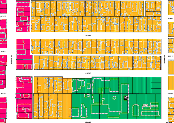 Above: The typical arrangement of alley-inlaid city blocks in Los Angeles, demonstrating the way they may bisect adjacent residential blocks (center, in yellow), serve as rear access for commercial properties (left, in magenta), or may be absent altogether (top). Alleys in Los Angeles do not typically bisect or run adjacent to schools (bottom, in green). (Source: ZIMAS.lacity.org) The cartography of Los Angeles has featured alleys dating all the way to the City’s era as a Spanish pueblo. Early administrative uses of the term “alley” in Los Angeles appear in Eduard Ord’s 1849 Survey of Los Angeles. After the end of the Spanish era and the adoption of Western urban planning, most districts in Los Angeles that were developed between the 1890s and the 1930s were planned with alleys bisecting each block. The alleys of Los Angeles met the same fate as those of other cities around the country; they became associated with blight and were subsequently paved and in many cases gated. Alleys are distinctly absent from many Los Angeles suburbs developed after World War Two. Starting in 1993, the year after the Los Angeles Riots and at the height of the crack epidemic, the City gave residents the option to gate their local alleys shut through a petition process. By the time the law was struck down by the California Supreme Court in 2004 (citing health and safety hazards), thousands of blocks of alleys had already been gated, further rendering them a barren and alienated space. According to Jennifer Wolch, et al. (2008, 2010), at present there are over 11,000 city blocks with accompanying alleys in the City of Los Angeles. The vast majority of the City’s alley mileage, quite surprisingly, is located within residential and mixed-residential areas, with just a quarter being located in areas zoned for primarily commercial and/or industrial use. This fact further suggests prescriptions on the part of early city planners that alleys be utilized for utilitarian and public works-related functions such as meter access and waste collection. SOME NUMBERS Alleys Across Los Angeles, by Number of Linear Blocks South Central = 3,315 San Fernando Valley= 3,298 Metro* = 2,564 Westside = 1,653 South Bay = 1,491 Lined up side-by-side, the total number of alley blocks amounts to 930 linear miles, a distance 100 miles longer than the distance from Los Angeles to El Paso using the 10 Freeway. *In this context, “Metro” refers to Downtown, the Eastside, and the Northeast side. (Source: Wolch, et al. 2008, 2010) II. Ecological Considerations Before green spaces are established, consideration should be granted to nearby (or even historical) land uses. Controversy arose, for example, during summer 2018 over the York Boulevard Park in Highland Park, the lot of which had contained a gas station as recently as the 1990s. Alleys adjacent to land uses like gas stations or mechanic shops should be ruled out as candidates. Additionally, Fuller and Warren (2008) found that high building density, especially in terraced areas, affects the quality and size of green spaces, which in turn affects the ability of wildlife to proliferate. It is tedious to get into comprehensive detail about every ecological consideration, but broadly speaking, alley repurposing would require human ecological considerations. Each alley reuse project should be treated on an individual basis. At the same time, a project as low-impact as a pocket park conversion in an alley should not generate the extent of environmental review that is required of large-scale building projects. III. Proposed Ideas for Repurposing Alleys (Including Woonerfs and Bike Lanes) As stated, the alleys of North American cities primarily take on the form of pathways on the rear sides of residential and commercial blocks, reserved for public service functions and deliveries. (There are plenty of notable exceptions, particularly in historic East Coast neighborhoods like Patchin Place in Greenwich Village.) Alleys in Los Angeles primarily serve these same utilitarian functions, as well as access points for rear garages and auxiliary housing units. Alleys in commercial areas serve as delivery receptacles. Other, less productive used of alleys, of course, include drug deals, auto repair, and graffiti battles. Despite their association with clandestinity and hazard, alleys in Los Angeles have enormous potential, both for locals and visitors to our city alike. Alleys can be repurposed as, among other things, multi-modal travel routes, green spaces, and recreational and interactional spaces. a. “Complete Streets” and Related Concepts On the broadest level, the complete streets concept is a discourse within new-urbanist planning whereby streets are designed and maintained as a safe option for users across age and physical ability, regardless of their preferred mode of transportation (or lack thereof). Arguably the most famous complete street concepts are the Dutch woonerfs. These alley-like networks prioritize foot travel and are inlaid into mostly-residential neighborhoods. Typically, woonerfs bisect residential blocks. Often, rear entrances to the adjacent residences are accessible via the woonerf. The open space of the woonerf itself is utilized for pedestrian circulation and as social and recreational space. Below: An example of a Dutch woonerf, with this woonerf being oriented around the rear yards of homes; sometimes, woonerfs can be oriented toward the front yards of homes. (Source: The Cycling Embassy of Great Britain) 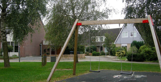 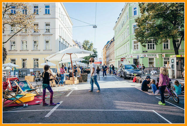 Above: An example of a German wohnstrasse. Note the mixed presence of cars and pedestrians. (Source: TheUrbanActivist) The Wohnstrasse in Germany are similar, except they bear more accommodation to automobiles than woonerfs. Other multi-modal equivalents around the world are home zones (England), shared zones (Australia), Zilaja zona (Russia), and zone residentielle (France). Santa Monica’s 3rd Street Promenade is one of the most prominent LA-area examples. In 1965, three blocks of 3rd Street between Wilshire Boulevard and Broadway were blocked off from through-traffic and dedicated to recreational and social space. “Alleys” around the world employ various methods of “traffic calming” to prioritize or exclusivize pedestrian travel, such as: curb extensions, turn tightening, road texturing, and narrowing or reducing the number of drivable lanes. However…. ...sadly, most back alleys in Los Angeles are a bit too narrow to be repurposed to match the form of Dutch woonerfs, Japanese yokocho, or German wohnstrasse. Luckily, there are plenty of other productive options. Take as our template... ...this sample of the enormous alley network inlaid into South Central. 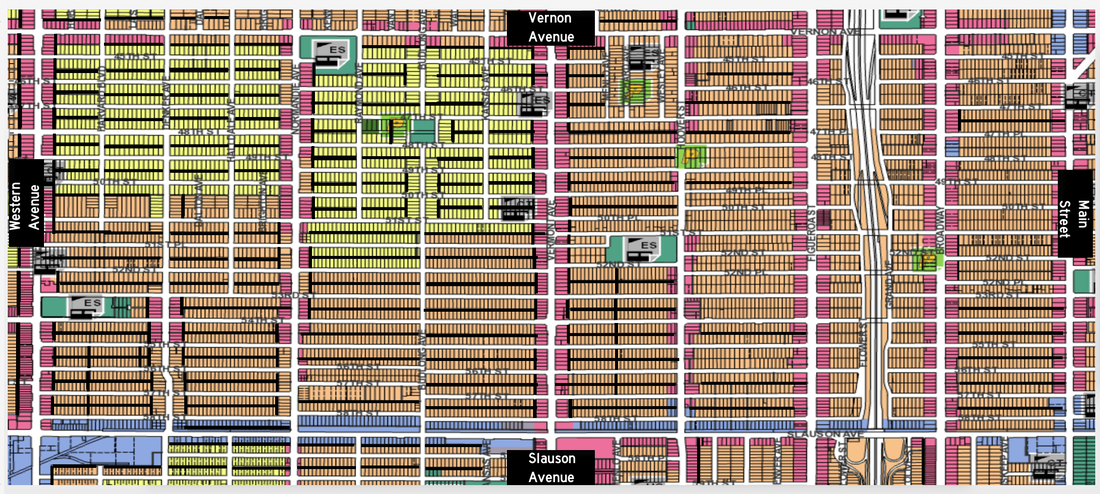 Above: A sample of street-alley configuration in South Central Los Angeles, with all alleys augmented with dark bars. The varying widths, lengths, configurations, and alignments of the Los Angeles alley network allow for diverse repurposing options. (Source: ZIMAS.LAcity.org) b. Circulation Locally, some alleys could be adapted into short-distance express lanes (accessible by permit) to alleviate congestion and traffic jams during rush hour. Other alleys could be dedicated as safe zones for light traffic, such as walkers and cyclists. Surface streets themselves would remain dedicated to heavier, longer-distance traffic. c. Bike Lanes This was an idea I pitched to one of my senior urban planning professors. If aligned properly, a series of alley blocks could be paved and dedicated to uninterrupted bicycle travel. Below: A contiguous and perfectly aligned contiguous stretch of alleyway runs west of Van Ness Avenue between Slauson Avenue and MLK Boulevard. That's nearly 2 miles! Perhaps this could be the Van Ness Cycleway? (Source: ZIMAS.lacity.org) 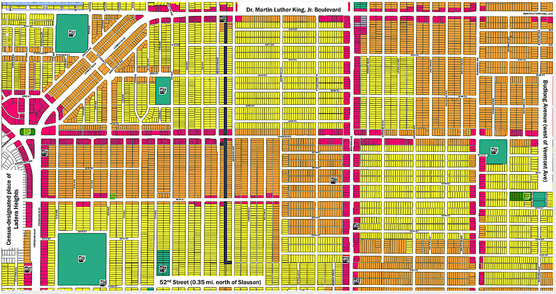 Aside from the installation of pavement, this repurposing would require some retrofitting. The inlets and outlets to each alley block would need to be narrowed or barred to prevent the intrusion of cars. Installation of safety features like emergency phones and surveillance cameras may need to be implemented in some districts. Depending on their respective widths, some alleys may have to be planned for one-way or two-way travel. d. Pocket Parks or other Social Spaces I know what you’re thinking—“Why on earth would I want to hang out in an alley?” Certainly, the current state of many alley networks in Los Angeles is neither welcoming nor sanitary. However, as we have discussed, the isolated backroads constituting European and Asian analogs of alleys serve as spaces of sociality, with the most notable examples being the Dutch woonerfs and Japanese yokocho. Given the length and widths of most Los Angeles alleys, it would difficult to accommodate activities that require wide open spaces. However, there are activities—such as board games, swings, slides and animal recreation—that require comparatively less space. Another possibility for the recreational repurposing of alleys is for the rear fences of backyards adjacent to alleyways to be removed. This would have the effect of conjoining several neighboring backyards into one large recreational area, thus creating wider spaces for sporting and encouraging interaction amongst neighbors. This repurposing would be most similar to the Dutch woonerfs, which bear a pedestrian presence amongst the front and rear of homes, essentially creating a strategic watch over the neighborhood from all sides. As with bike lanes, infrastructural improvements need to be implemented before alleys can become spaces of sociality and recreation. This includes but may not be limited to: surveillance, emergency phones, traffic calming, water fountains, and lighting. 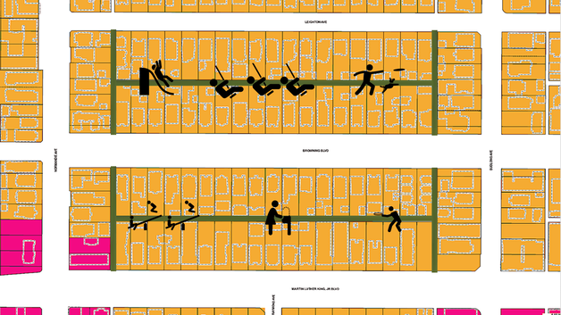 Source: ZIMAS.lacity.org and TheNounProject......because I haven't learned how to use SketchUp yet ;-) e. Ecological Replenishment Alleys experience many of the same maintenance-related issues as surface streets, a major one being surface runoff. While storm gutters ostensibly handle the majority of rainwater and surface runoff, not every block of every street in the topographically diverse and large Los Angeles County is perfectly engineered at all times. Paving the surface of alleys while leaving the very outer edges unpaved would essentially form a stormwater drainage inlet. A properly bevelled finish of the alley's outer pavement would allow rainwater, wastewater, and other surface runoff to settle into the unpaved outer perimeter of the alley. Inlet piping could drain to the sewers, while the bare land could assist with groundwater recharge. Secondly, the alley's outter perimeter could further be repurposed into a wastewater planter, in which absorbent plant species absorb some of the surface runoff. Ideal species for this function are those capable of rapid absorption, dry growth, drought tolerance, and/or twining. Some diverse possibilities include: Sticks-on-fire (a succulent, Euphorbia tirucalli), Yellow jasmine (or “yellow jessamine”, Gelsemium sempervirens), Toyon bush (Christmas berries, Heteromeles arbutifolia), and Wisteria vine species. If there is concern that the location surrounding a particular alley poses risks of bacteria vectoring in the unpaved planters, then the entirety of the alley can be paved with water-absorbing concrete, such as the acclaimed Topmix or Tarmacadam products. Unlike conventional sand-based concretes, “thirsty” concretes are topped with granite of varying coarseness. Underneath the granite is a median layer enabling different levels of absorption, depending on the location and application. CONCLUSION The repurposing of urban alleys has enormous implications for districts all over Los Angeles. However, they are most invaluable to the park-deficient districts of the San Fernando Valley, Eastside, and South Central. These districts also tend to be the most crime-afflicted in the City. With a lack of open and secure spaces to exercise, these districts also tend to be some of the unhealthiest in Los Angeles. The poor health of many South Central districts is compounded by the fewer number of grocery stores per square mile than other districts. Further these districts also have less proximate access to light rail than most of Los Angeles. The extensive alley networks all over Los Angeles possess enormous potential for repurposing as social spaces, ecological spaces, bike paths, and pocket parks. In most cases, reasonable environmental review is an order, taking into particular consideration nearby land uses. In nearly all cases, various infrastructural improvements are necessary to make repurposed alleys safe and secure spaces for prescribed functions. Planners may also consider dedicating continuous stretches of alleyways to single uses, not mixing or alternating the functions connected alley segments. Each project should be implemented on a permit basis, and dependent on the notification and/or agreement of residents on each block. The level of noise produced by each repurposed alley should be taken into consideration during the planning process. BIBLIOGRAPHY Ben-Joseph, E. (1995, March/April). Changing the Residential Street Scene: Adapting the shared street (Woonerf) Concept to the Suburban Environment. Journal of the American Planning Association, 61(4), 504-515. Davies, R. G., Barbosa, O., Fuller, R. A., Tratalos, J., Burke, N., Lewis, D., . . . Gaston, K. J. (2008). City-wide relationships between green spaces, urban land use and topography. Urban Ecosystems, 11(3), 269-287. Fuller and Warren, et al. (2008). Garden bird feeding predicts the structure of urban avian assemblages. Biodiversity Research. Martin, M. D. (2002). The case for residential back-alleys: A North American perspective. Journal of Housing and the Built Environment, 17, 145-173. Retrieved October 1. Rudd, Hynda (2007). The Development of Los Angeles City Government: 1850 to 2000. Los Angeles: Los Angeles City Historical Society. Vol. 1. Sloane, D. (2012) Planning Los Angeles. Chicago: American Planning Association Planner’s Press. Wolch, J. R., Byrne, J., & Newell, J. P. (2014). Urban green space, public health, and environmental justice: The challenge of making cities ‘just green enough’. Landscape and Urban Planning. Wolch, J., Newell, J., Seymour, M., Huang, H. B., Reynolds, K., & Mapes, J. (2010, October/November). The forgotten and the future: Reclaiming back alleys for a sustainable city. Environ. Plann. A Environment and Planning A, 42(12), 2872-2897. Various Authors (Various Years). The Homicide Report. Los Angeles: Los Angeles Times. ZIMAS.lacity.org. **Contains GIS layers for the Ord Survey. The Ord Survey can also be referenced through the University of Southern California Digital Collections.
0 Comments
Leave a Reply. |
Archives
December 2022
Categories
All
|
 RSS Feed
