
TABLE OF CONTENTS :
|
JUMP, JIVE, and
HARMONIZE: The Eastside Sound of Los Angeles As It Relates to the National "Garage Rock" Narrative
INTRODUCTION
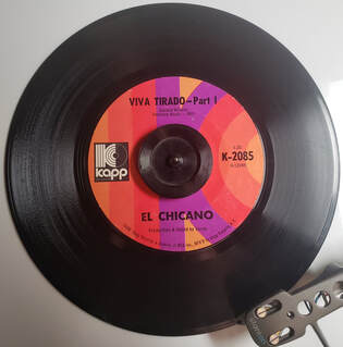
The Eastside Sound of Los Angeles has always been part of the soundtrack of my life. Wax copies of “Where Lovers Go” and “Angel Baby” were highlights of my parents’ collections, as were compilations like “East Side Story” and “Barrio Chingon.” El Chicano, Los Lobos, or Tierra could usually be heard blaring from a hi-fi in my music teacher’s Boyle Heights studio–and, in fact, El Chicano keyboardist Bobby Espinosa could often be seen there. Otherwise, during the summer months, I could be found at the North Figueroa Lowrider Festival, where songs like “Queen of My Heart,” and “As I Sit Here” filled the air. Significantly, I crossed paths with Eastside legend Lalo Guerrero at a music festival in Hermon when I was an adolescent– I had just started playing music at the time.
Along the way, we will also learn some new musical parlance!
VV Click "READ MORE" to continue reading VV
1 Comment
Greetings to my readers…and after a considerable pause, too! I hope this message finds all of you doing well. The reasons for my long pause are threefold. Firstly, I have been wrapping up graduate school, which I began in January of 2020—right before all the shutdowns and the overturning of the world that followed. I am happy to say that it was an otherwise enjoyable process, and that I graduated in June 2021. Our graduation ceremony was held at the beautiful Memorial Coliseum. Secondly, I have been particularly busy since March 2020; in addition to my preoccupation with graduate school, I was laid off from my County position, leading me to work several part-time jobs to hold everything down. Lastly, during this period I had the opportunity to pursue some things that I otherwise do not usually have the opportunity to do. I biked ten-plus miles a day, visited family and friends, built my professional website, traveled a bit, processed dozens of rolls of 35 mm and Super 8 film that I had taken as far back as 2007....and more. It will be good to be back writing again—and hopefully regularly. I would like to resume after my long hiatus with some commentary on urban planning and development policy. VV Click "READ MORE" below to continue reading VV
KEEPING UP WITH THE CROOKS: The Militarization of the Police in American Cities and How it Did Not Erupt From A Vacuum INTRODUCTION Though not a particularly new phenomenon, the militarization of the police has become a buzzword in American political life in the past several decades, particularly the past decade. Heavily militarized responses to events like the 1999 anti-WTO protests (which were broadcast across the world) made the militaristic capabilities of the police well-known to the public. Los Angeles has seen its own police force armed to the teeth on some occasions, such as the 1965 and 1992 riots and, more recently, the 2000 Democratic National Convention protests and 2007 May Day demonstrations. I was blocks away from the 2007 event as it transpired. Following the decision not to file charges against St. Louis police officer Darren Wilson (who shot and killed Michael Brown), large-scale protests against police brutality and demands for policy changes became more frequent than ever before. The incidence of these protests increased still following the brutal death of George Floyd in May 2020 at the hands of Minneapolis police officers. As always, the presence of elite, paramilitary-like law enforcement units were a noticeable presence at these demonstrations.
As with every other aspect of modern life, the militarization of the police has been adapted into a political agenda setting tool. Public officials have weaponized the funding and defunding of police departments across the nation, turning the very support for policing into yet another politicized aspect of American life. Further, many misleading narratives about policing and use-of-force have become mainstream in educational institutions, in the media, and within popular culture. This article points out how the militarization of police did not erupt out of a vacuum; rather, that it was the result of law enforcement’s need to compete with the disproportionate firepower, tactics, and malevolent intentions of criminal elements. It is not a complete account of the militarization of police, nor is it a justification or a condemnation of the militarization of the police. Rather, it explains how the militancy of policing increased as a response to the tactics of criminal elements, rather than emerging out of malevolent intentions on the part of the government. PRESS "Read More" BELOW TO CONTINUE READING SHOULD We Keep Drilling, Baby? THE DISTRIBUTION OF OIL WELLS IN THE CITY AND COUNTY OF LOS ANGELES7/31/2020 SHOULD We Keep Drilling, Baby? THE DISTRIBUTION OF OIL WELLS IN THE CITY AND COUNTY OF LOS ANGELES Los Angeles County (and Southern California in general) is rich in oil, and as such is home to a vast overlay of oil fields. Angelenos may have seen them driving through the South Bay, Santa Clarita, or Long Beach. Others may be familiar with the smaller fields hidden in plain sight amongst developed urban areas throughout Los Angeles County. In fact, as we will learn, Southern California is home to some of the largest oil fields in the United States. Los Angeles County by itself contains over 20,000 oil wells disseminated over 70 oil fields and 4,753 square miles. Most of these oil wells are out in the open, but many are hidden in plain sight within developed urban areas. 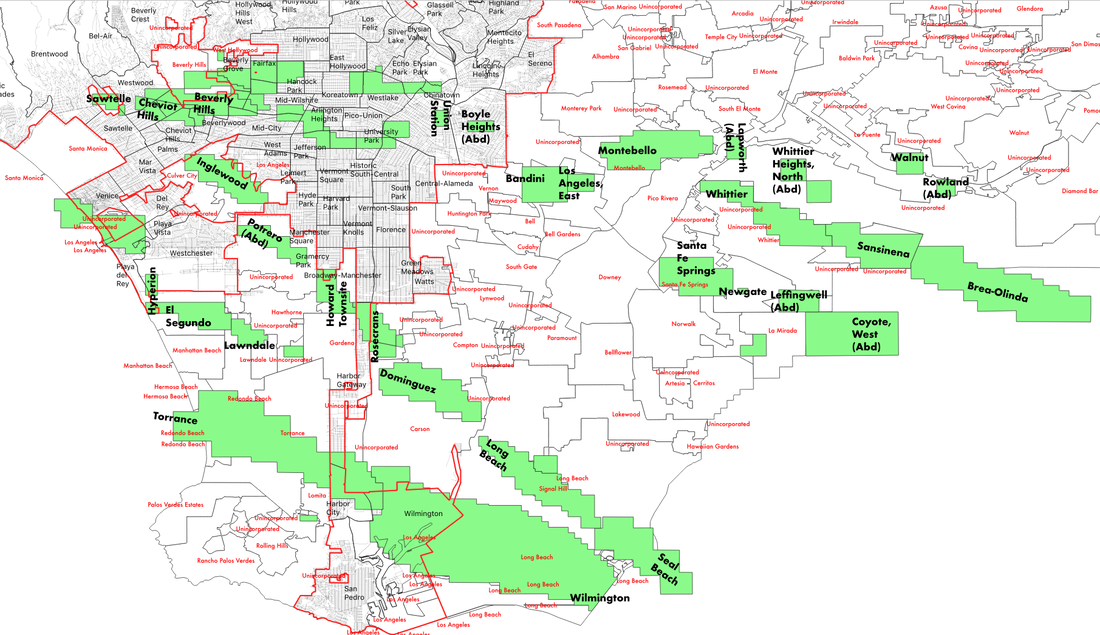 CLICK "READ MORE" TO TURN THE PAGE! V V V V WAS MY LOS ANGELES NEIGHBORHOOD REDLINED? A Detailed Look at Los Angeles' 1939 HOLC Maps.6/30/2020 WAS MY LOS ANGELES NEIGHBORHOOD REDLINED? A Detailed Look at Los Angeles' 1939 HOLC Maps by Damian Gatto Always an enthusiast of United States Presidential history, I never quite understood why Franklin Roosevelt is remembered as such a progressive president. On top of his economic statism and the internment of 130,000 law-abiding citizens (127,000 Japanese and thousands of Italians and Germans) during his presidency, Roosevelt signed the National Housing Act of 1934 into law, which in-turn authorized the creation of the Federal Housing Administration. The FHA sponsored a private firm called the Homeowners' Loan Corporation (HOLC), charging them with the creation of a system that would guide the government in distributing aid to prevent foreclosures across the country. As a visual aid, the HOLC produced "residential security maps" indicating their assessment of real-estate stability in 239 U.S. cities, now referred to in the shorthand as "redlining maps" or "HOLC maps." The maps were overlaid with a four-color gradient indicating different levels of investment stability. From highest to lowest, these colors were: Green - "Best" Blue - "Desirable" Yellow - "In-Decline" Red - "Hazardous" One peculiar thing about the 1939 HOLC maps is that some of the criteria used to assess investment risks are fairly common in real estate, while other criteria are virulently racist, classist, and xenophobic. On the one hand, these color grades relied on some fairly typical real estate assessment criteria, such as: - Intrusion of industry or other noxious land uses, or proximity to those land uses - Mixed adjacent land uses, in general - Age of the community's housing stock - Rate of growth - Presence of multi-family housing of any amount, size, or kind (even a compact duplex) - Presence of nondescript architectural styles - Quality of construction - Availability and profusion of amenities (such as shops, transportation, attractions) - Availability or lack of infrastructure (such as sewers, electricity, hydrants) However, redlining maps are most discussed within modern social sciences disciplines for their use of race, class, religion, and country of origin as criteria for determining the security of real estate investments in many communities. In a country that was, at the time, largely biracial (at 89% White and 9% Black) and comprised of two or three disparate income categories, the consideration of race and class basically meant that a community's high percentages of Black and/or low-income residents were enough for the HOLC to assign a negative color grade. It is for these reasons that the HOLC are regarded as the pioneers of racial redlining. The term "redline" has also found its way into the vernacular more broadly to mean "set apart as hazardous or undesirable." In Los Angeles and other cities along the West Coast, HOLC contractors ran into a slight challenge. The HOLC contractors seemed to have only come expecting to assess "White-versus-Black" makeups of an area, being that the Area Description sheets only contained a line reading "Percentage Negro." However, cities like Los Angeles, San Fransisco, and New York were not so ethnically homogenous or dichotomous as many other places in the country. As such, the HOLC contractors wrote in many of the other ethnic and religious groups they encountered. Was MY Los Angeles Community Redlined? The short answer is, it is very likely that your Los Angeles County community was redlined (meaning that issuing loans in such a neighborhood was "hazardous") or given an assessment of yellow (meaning that the community was "definitely in decline"). The HOLC came through Los Angeles County and turned the cartography of the city into a Jackson Pollock mural. 22% of the city was redlined, 46% was yellowlined, 20% was bluelined, and 12% was greenlined. In other words, over two-thirds of the County of Los Angeles--68%, to be exact--was no bueno in the eyes of the HOLC. Redlined communities could even be found right next to greenlined ones--and in some places, the effects of these disparate assessments are still visible today. Below: Macro-level HOLC Residential Security Map of Los Angeles County, covering the Westside, Mid-City, Hollywood, South Central, East LA, Northeast LA, and some of the Gateway Cities. (Source: University of Richmond) 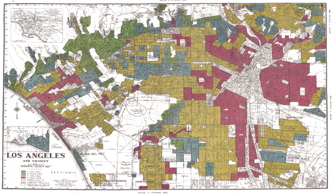 Most academic sources reproduce the raw map itself--which is great--but I decided to generate my own renditions of the HOLC maps, overlaid with current Los Angeles neighborhood boundaries. (Although there aren't official, administrative boundaries of LA 'hoods --just "agreed-upon" boundaries-- these imagined boundaries are what many Angelenos swear by and thus act as a more useful point of reference than the much more arbitrary lines drawn by the HOLC). Many published sources also fail to go into detail about geographic boundaries like streets or hills. Many sources also fail to mention the area description sheets attached to each area, listing the HOLC surveyor's "rationale" for their grades. I thus decided generate my own maps as a means to take a detailed look into how different communities in our city have been afflicted (or unscathed) by the 1939 HOLC map grades. I generated my renditions of the HOLC maps using the QGIS platform, and shapefiles for "Los Angeles Times Neighborhood Boundaries" and "1939 HOLC Redlining Areas" as my data. These are available via geohub.lacity.org and hub.arcgis.com . CLICK "READ MORE" BELOW
to turn the page and find out why your Los Angeles neighborhood was (or was not) redlined!
BREAKING:
FATAL Shooting In Downtown Los Angeles Heard Over LAPD Radio Frequencies This Could Be the First Official Homicide of the 2020 Los Angeles Riots. LISTEN TO THE LAPD RADIO CRIME BROADCAST HERE
Like many Angelenos, I have been doing my best to keep up with the protests occurring in City of Angels and across our nation. I don't really watch television, and I am not satisfied with many major news providers.
"Central units: Possible shooting just occurred. 801 South Olive [...] Suspects last seen southbound Olive from location [...] Approximately 15 gunshots heard. Possible victim is in a dark blue Bentley [...] Vehicle disabled in the middle of the street [...] Suspects fled the location with the victim's silver briefcase."
Police arrived in less than a minute and covered the body. At 8:05 PM, 25 minutes after the shooting, the helicopter pilot is heard saying:
"I can't stress it enough...we need to have this [blockade] in place, like, real quick here. If [the rioters] see that guy under the sheet, it is not going to be good."
CLICK "READ MORE" BELOW to hear the police scanner broadcast!
The Highland Park Neighborhood of Los Angeles: A Case Study and Profile of Development Table of Contents PART ONE - CONTEXT, GOVERNMENT, AND LAND USE REGULATIONS Section I – Locational Context, Demographics, History, and Perceptions of Highland Park Section II – Governance of The City of Los Angeles and the Highland Park District Section III – Land Use Regulation in Los Angeles and Highland Park PART TWO - LOCAL DEVELOPMENT PART THREE
THE GREENEST BUILDING IS ONE THAT'S ALREADY THERE: The Enormous Potential For Adaptive Reuse in Los Angeles by Damian Gatto I. INTRODUCTION AND HISTORY Adaptive reuse is precisely what it sounds like: the adaptation and repurposing of a building (or other structure) for uses other than those for which it was originally designed. Adaptive reuse most commonly involves the rehabilitation of non-housing structures for use as housing, although some variation exists amongst the former and resultant uses of these structures. Los Angeles instituted its own adaptive reuse program in 1999 in the form of a zoning code amendment named the Adaptive Reuse Ordinance. The passage of the “ARO” followed a long series of events in the 20th century: the decline and destruction of neighborhoods in and around Downtown Los Angeles, the subsequent institution of eight Historic Protection Overlay Zones, and finally, very admirable early attempts by activists and investors like Ira Yellin, Tom Gilmore, Wayne Ratkovich, and others during the late 1970s to early 1990s to perform what would later be described as “adaptive reuse.”
During the late 20th century, Yellin (with the help of the Community Redevelopment Agency and the Metropolitan Transit Authority) successfully rehabilitated the Laughlin Building for residential use, as well as the Grand Central Market and Bradbury Building for commercial and governmental use. Gilmore was behind the restoration of many buildings in the Old Bank District. Ratkovich, for his part, spearheaded the beautiful restorations of the Oviatt Building, the Wiltern, and the Chapman Drive-in Market in Koreatown. In the midst of this, Los Angeles City Planner Alan Bell began writing the drafting the first versions of the Adaptive Reuse Ordinance in 1997-1998. Announcing: My 2020 Preservation Efforts! by Damian Gatto Having spent many years restoring historic homes, many more immersed in the details of eclectic Southern California architecture, as well as a summer volunteering in the Office of Historic Resources, I eventually realized my calling when I was an undergraduate to research and preserve historic properties in a city that is known for reinventing itself.
In this article, I am pleased to announce my historic preservation endeavors for the year 2020. I have listed the entries in the order by which I plan to submit them to the Office of Historic Resources. I will upload the case files of each monument as I submit them to the Historic Resources Commission. UPDATE April 2021: With the onslaught of the COVID-19 pandemic, its effects upon (among many other things) the pace of government business, my culmination of graduate school, and my work schedule, my 2020 preservation efforts have been greatly slowed to where I have only been able to submit the nomination for the property on Boylston Street. On top of this, the Office of Historic Resources has changed their rules for nomination submittal to where it must be done in-person and through appointment. I suspect this is their way of pacing down the sheer number of nominations that they receive in a given period of time. I will keep you all updated with new developments as they occur. CLICK "READ MORE" BELOW |
Archives
December 2022
Categories
All
|
 RSS Feed
