
TABLE OF CONTENTS :
|
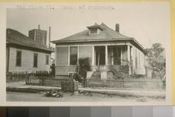
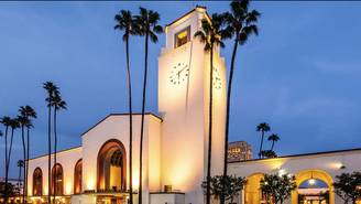
IT WAS WHERE UNION STATION IS NOW: A History and Genealogy of the Macy Street Neighborhood PLUS: A Reflection Upon the Plague In Los Angeles and the Current Typhus Scare. BONUS: The Top Secret "Ratatorium" That Still Stands by Damian Gatto Bottom left: The Lajun family's Date Street home in the Macy Street neighborhood, which would later be the epicenter of the 1924 Los Angeles Plague Outbreak, juxtaposed with Union Station (bottom right) which would be built in the neighborhood's place 14 years later. (Source: Calisphere Digital Library [Lajun home] ; unionstationla.com [Union Station] )
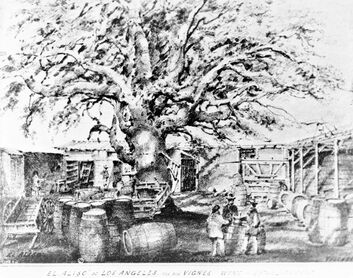
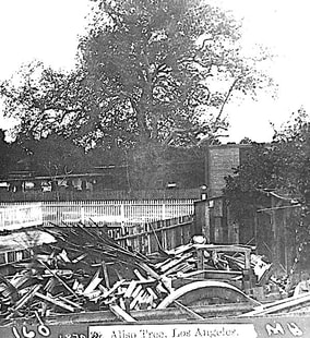
Union Station is one of Los Angeles' great architectural gems, representing an elegant fusion of Art Deco, Mission Revival, and Spanish Revival features. It was designed by John and Donald Parkinson and constructed by Robert E. McKee Inc. during the period 1937 to 1939, and expanded upon several times thereafter. It is by far the busiest transportation hub west of the Mississippi River, and the 12th busiest in the United States overall, serving over 100,000 passengers on any given day. What many do not know is that Union Station's rise to prominence came after a long and contentious development process, one marked by racist and classist overtones. As was the case with Dodger Stadium and the Terminal Annex (which were proceeded by the Chavez Ravine [Palo Verde, La Loma, & Bishop] and Naud Junction neighborhoods, respectively), so too did the construction of Union Station demand the total razing of a whole neighborhood that lay in its path...... ......The Macy Street neighborhood. Actually....... the site was originally home to the village of Yaanga, one of the largest Tongva villages in pre-colonial Los Angeles. Its inhabitants, the Yaangavit, occupied an area that spanned approximately from modern-day Fletcher Bowron Square to the west, the Los Angeles River to the east, 1st Street to the south, and the base of Radio Hill to the north. The Yaangavit cultivated sages, grasses, and corn, the last of which they ground and fried into pinole. They smoked from baked clay pipes. They also paid homage to an ancient Sycamore tree dating from the 15th century, known to the Spaniards as "El Aliso." This tree was central to the Yaanga settlement, so much so that it served as a unit of measurement for the Yaangavit. It was also used as a reference point by the pobladores--the founders of Los Angeles-- and by traders throughout the southwest. Between the arrival of the Portola expedition and the 1840s, the Yaangavit were exploited as slave labor. The original Yaanga village stood until circa the 1810s, when it was forcibly relocated southward to the vicinity of what is now Alameda and Commercial Streets. For the Tongva, this marked the beginning of a series of forcible relocations around the city. The City Council even passed a law that required the Tongva villagers to work or be arrested. In 1845, the villagers were again relocated to a site called Pueblito, which lay across the Los Angeles River in what is now Boyle Heights. In winter of 1847, Pueblito was completely razed, and the forcible quartering of the remaining Yaangavit into Anglo and French homes was finalized. El Aliso, the last trace of the village of Yaanga, was slowly cut down throughout the 1890s. (In case you're wondering, the tree stood roughly at the northwest corner of Garey and Commercial Streets.) The only evidence of the Yaanga civilization that remains are the archaeological remains that have been uncovered in various stages beginning in 1937-1939 with the construction of the Terminal Annex Building and Union Station.
The street named "Macy" has its origins in 1851 with the arrival of Doctor Obediah "Obed" Macy and his family, who moved from Indiana on an oxen-pulled wagon. During the nine-month journey, their son Charles died of cholera. Once settled in El Monte and later Los Angeles, Obed purchased the Bella Union hotel, which stood until from 1835 to 1940 upon the site that is now Bowron Square--once the focal center of the Yaanga village. Oben would also establish himself as one of the first physicians in the new American territory of Los Angeles. He even opened a bathhouse called The Alameda, one of the budding city's first. Obed and his wife Lucinda eventually raised thirteen children, two of which--Obediah Jr. and Oscar-- went on to become civic leaders in Los Angeles. On July 19th, 1857, six years after his arrival in Los Angeles, the elder Obediah Macy died. The street bearing his surname survived its first attempted erasure in 1920 when the City Engineer recommended consolidating the street into Brooklyn Avenue, a proposal that the Native Sons of the Golden West lobbied strongly against and effectively stymied. (Ultimately, Macy Street, Brooklyn Avenue, and part of Sunset Boulevard would be renamed Cesar Chavez Avenue in 1994.) By the mid-late 19th century, as Los Angeles was becoming an increasingly Anglo-American city, the Macy Street neighborhood, or the "Mexican section" (called as such by newspapers and civic leaders of the time) became one of Los Angeles' first melting pots. It is perhaps best remembered as the first Chinese enclave in the city--the original Chinatown. It was also home to one of the city's first Italian enclaves, and by the turn of the 20th century bore a predominance of Mexican residents.
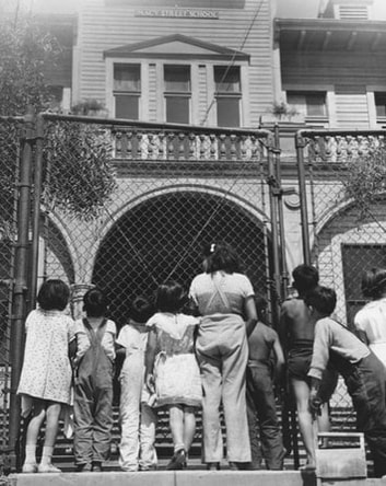
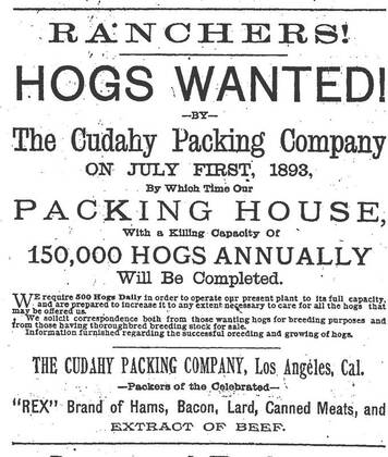
Top left: The Macy Street School (Source: Los Angeles Public Library) Top right: An 1893 advertisement by the Cudahy Packing Company (Source: Los Angeles Times) Many immigrant entrepreneurs realized the American Dream in this community. In the mid-19th century, Frenchmen Louis Bauchet and Louis Vignes operated their own vineyards north and east of Union Station where the streets that bear their surnames now run. The Sepulveda family's land holdings and vineyards were located at the corner of Date Street and Ogier Street. The German-American Kerckhoff & Kuzner Lumber Company supplied lumber for countless early structures in the city. The Irish-founded Cudahy Packing Company was the City's then-largest slaughterhouse. The Italian immigrant-founded American Foundry was located here. Countless Chinese restaurants and laundries also operated in the Macy Street neighborhood. Like the humble communities of Palo Verde, La Loma, Bishop, and Naud Junction, this humble community in the city's 8th Ward was not unlike the one you and I live in. Children froliced in the streets. Honest, hardworking people provided quality goods and services. The Macy Street School, which stood for less than two decades before being ripped down, was an elegant edifice and one of the city's first schools built for working class youth. The Catholic-run Sisters of Charity held fundraising events that brought together men and women of all denominations. However, to many of the city's politicians and elites, the industrial, working-class community was too unsightly to continue in its place, given the much more grandiose plans that they had for the site. By the early 20th century, they began to search for pretexts to get rid of the community once and for all. In fall of 1924--two years before the ballot initiative that sealed the community's fate--the elites of the city found their first excuse to tarnish the community. Click "READ MORE" below.
9 Comments
THE PHILOSOPHER ON ALLESANDRO STREET: A Tome of Letters and Other Writings by Edendale Nature Boy Dr. Edgar Colburn Found Buried in a Santa Clarita Bookstore !!! by Damian Gatto INTRODUCTION You may have read my piece from October 2017 (originally written in 2014) entitled The Nature Boys of Edendale about the Semi-Tropic Spiritualists, the Landacres, and the Colburn Biological Institute, all of whom resided on a tract located southeast of Allesandro Street in the late 19th and/or early 20th centuries. Landacre came to Southern California from his native Ohio to rehabilitate himself from a respiratory illness (as did many others at that time), and thereafter realized his passion for wood engraving and printmaking. The Spiritualists and Colburn came to the West Coast in the late-19th century and early-20th century, respectively, with their alternative philosophies about the occult, astrology, and metascience. Colburn, for his part, was the pioneer of a field called "medicology." There had been a decent amount of information on the Landacres and the Spiritualists, but the Colburns--not so much. The Colburn Institute appeared on my radar via a blog comment by a longtime resident of Elysian Heights who recalled that, adjacent to the Semi Tropic Spiritualist Tract, there once stood “a house with a koi pond and a pitched roof” that “mysteriously burned down around 1979.” As it happened, I had a photograph documenting this to be true. 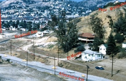 Above: A photo dating from the 1960s construction of the Allesandro Freeway, depicting a structure on stilts with a brown shake hipped roof, just to the right of center. This would be the hipped cottage spoken of in the aforementioned blog comment. (Source: Futterer family; the Holyland Exibition) CLICK "READ MORE" BELOW
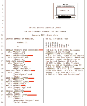
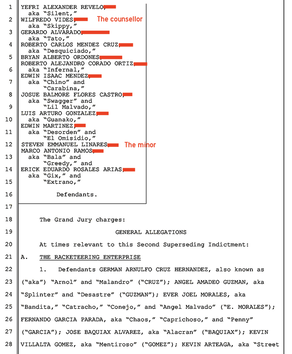
22 MORE SCOOPS: The Second Trump-Era Indictment Against MS-13 (called "Operation Foot Clan") Unsealed this Month INSIDE: The Monstrous "503" Faction of the Gang, 5 Brutal Murders, and How Facebook Addiction (?!?!) Helped Support the Case Against the Fulton Locos and "503" Cliques by Arturo Pimentel Asphalt Island Contributor Introduction and Brief History This month, the District Court of the Central District of California unsealed another RICO indictment against the Mara Salvatrucha 13 (MS-13) gang in Los Angeles, the second indictment against the gang executed under the Trump Administration. While the first indictment from May 2017 covered hundreds of overt acts committed by the Los Angeles chapter of the gang at-large over the course of a decade, this second indictment focusses specifically upon on MS-13 Los Angeles' Fulton Clique--the San Fernando Valley subset-- over the course of just a few years. A couple of incidents from May 2017 are even revisited in this newest indictment--most notably, the Little San Salvador murders.
MS-13 originated in Pico-Union in the early 1980s as “Mara Salvatrucha Stoners.” A family friend, whose upbringing in Pico-Union during this time inspired him to become a cop and then a prison guard, tells me that the 7-11 on James M. Wood Boulevard and Westmoreland Avenue was where the first clique formed. Behind this 7-11, he says, they would hang out, listen to heavy metal, and do drugs. This would explain the etymology of the gang's "7-11" Clique. The pre-ABC v. Thornburgh exploitation of Central American immigrants, the popularity of methamphetamine, the rise of tough-on-crime policy, as well as harassment and ostricization by other immigrant groups bolstered the early members of MS-13. Deportations of Central American immigrants (including many gang members) under the Reagan administration, once thought to be a sure solution to the issues at hand, only frustratingly expanded the organization's reach. Below: A list of MS-13 cliques, which can be found in the indictment's preamble. 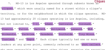 MS-13 cliques sprung up all over Los Angeles throughout the 1980s and 1990s; a pretty thorough list of these cliques is included in the indictment's preamble. The Mexican Mafia assumed control of the gang in the early 1990s. According to the FBI's National Gang Threat Assessment Project, the gang is presently active in 10 states (with most activity occurring in California, Maryland, New York, Virginia, and Texas) and throughout Central America. There are 10,000 members inside United States, and close to 50,000 outside of the United States. CLICK "READ MORE" BELOW
THE EAST SIDE OF SOUTH CENTRAL (aka Historic South Central): A Brief History and Architectural Tour.6/30/2019 THE EAST SIDE OF SOUTH CENTRAL (aka Historic South Central) A Brief History and Architectural Tour by Damian Gatto
With its diverse socio-cultural history, architectural gems, and closely-knit communities, the East Side of South Central is one of Los Angeles’s oldest residential districts and one of its first suburbs. The district is bound roughly by Washington Boulevard (N), the City of Vernon (E), Main Street (W) and Slauson Avenue (S). Central Avenue, the district’s namesake, runs prominently throughout South Central and all the way to Del Amo Boulevard in the City of Carson. Much of the future neighborhood was included in the City of Los Angeles' original 1781 imperial land grant, but it remained largely agricultural until the mid-late 19th century. Even then, residential development in the East Side of South Central predates the West Side of South Central by over three decades, commencing in earnest around the 1870s. The community's antiquity reflects in the historic architecture that appears throughout the district. 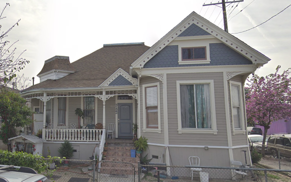 (Above: Some early residents of South Central, expatriates from Bunker Hill, sure brought their architectural sensibilities with them. This is a beautifully restored Queen Anne Victorian on 32nd and Maple, with Second Empire influences.) (Source: the author.)
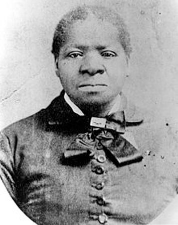
I. Early History and Biddy Mason This community, like relatively few other districts of Los Angeles of the time, contained a fascinating mix of people across race and class. The earliest residents included fire fighters and police officers, such as Officer Cecil S. Bowman, who resided at 1000 East 32nd Street and died in the line of duty on June 8th, 1911. Many early immigrant entrepreneurs purchased homes in the Central Avenue District, as it was first known. Peter Mayer, who was born in Colorado and ran one of the nation’s largest leather suppliers with his father, P. Mayer Leather Works, retired to Los Angeles in his old age, living on East 34th Street. Others commuted to Downtown on the Red Car trolley to work in factories or to help build the railroad. Still others were day workers who built homes for the more privileged, as my genealogies on Chavez Ravine, the Naud Junction neighborhood, and the Macy Street neighborhood have revealed. Even further still, early residents included Anglo residents who had originally lived in Bunker Hill, but in their old age had decided to retreat to early suburbs south of Downtown, such as South Park. However, the residents who would come to define the area's cultural history were descendants of freed African-Americans and their families. They initially moved into an enclave near Spring Street known as the "Brick Block" and congregated around the landholdings of a woman named Biddy Mason. A tremendously successful and charitable woman in her own right, Biddy Mason donated considerable sums of her living to charity, sheltered the poor, and risked her life to help fight smallpox, which took the life of her young daughter. For this, Biddy Mason is one of the most important pioneers of early Los Angeles. The early African-American community in Los Angeles history was thus solidified with this congregation around Mason’s landholdings, along with Mason’s founding of the First AME Church, which is still in existence. However, many also sought to escape the ill habits of certain downtown neighborhoods, particularly those east of Main Street, which had become home to flop houses and red light districts. As such, they moved directly south along the Central Avenue Corridor and started anew in this suburban neighborhood, the Central Avenue District. By the 1910s, the California Eagle was calling the Central Avenue District the “Black Belt” of Los Angeles. Immigrants from all over the world also arrived in South Central, chiefly from Japan and Italy. Now transitioning out of its days as a mostly-White suburb, the Central Avenue district became attractive to working-class immigrants because it proximity to (and yet isolation from) Downtown’s business districts, as well as its being served by the streetcar. Even more African-American residents arrived in the neighborhood in the early 1940s due to the promise of wartime manufacturing jobs and the decline of other cities and towns across the country. By now, the Central Avenue District, which had been redlined in the 1939 HOLC surveys, had become a decidedly low-income area of the city. Nevertheless, the neighborhood continued to prosper as a center of working-class creativity and entrepreneurialism for generations. With, first, the abolition of racially-restrictive housing covenants in 1947, and then with integration policy in the late 1960s, African-Americans moved into the West Side of South Central, as well as other districts around Los Angeles like Mid-City and Baldwin Hills. Beginning in the 1980s, Latinos began settling in the East Side of South Central in large numbers. It was a first-stop for many first-generation immigrants. Others relocated in an attempt to escape the violence of districts like MacArthur Park and Boyle Heights--only to find themselves in one of the most violent LAPD divisions, Newton Division. Shootin' Newton. In 1988, the neighborhood had more completed applications for immigration amnesty than any other in the nation. While South Central and Southeast LA County cities like Compton had once been the focal point of the nation's largest Black community, between the 1970 and 1990 Censuses, the black population of South Central declined by 32%. By the 2000 Census, the East Side of South Central (by then coined “Historic South Central”) was one of the top 20 Latino-predominant statistical areas in Los Angeles County. As of the 2010 Census, there are 19,474 people per square mile, one of the highest densities in both the City and the County. A quarter of households are headed by single mothers, also high for the City and County. The population is quite youthful; the average age is 23, and nearly half are under the age of 35. (Below: An 1899 vernacular cottage with containing the shell of what used to be a stable.) (Source: Google Street View) 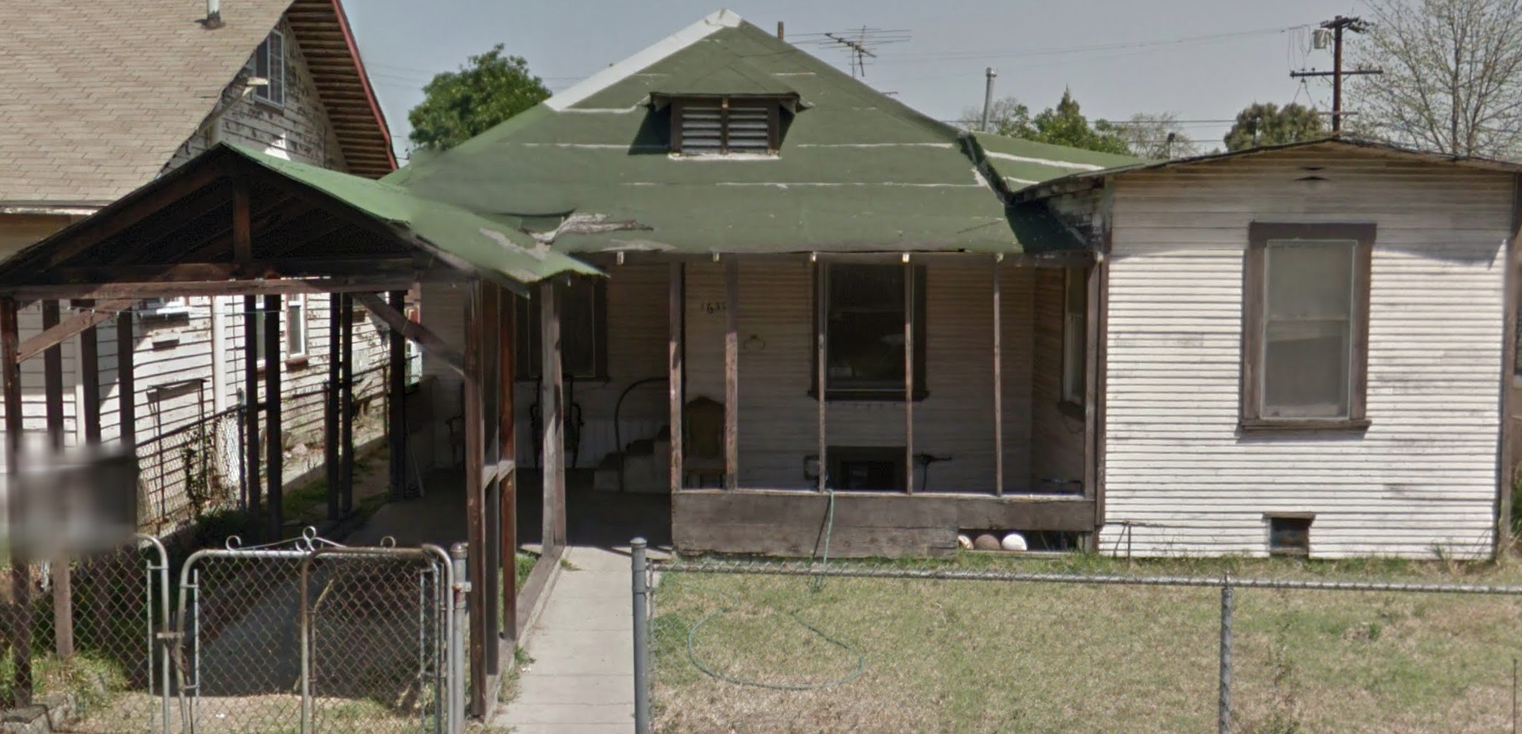 Today, the East Side of South Central remains a humble, working class community on Los Angeles' border with the industrial city of Vernon. The neighborhood’s historic, low-rise nature is reminiscent of how much of Los Angeles looked until the early-mid 20th century. Some residential blocks closer to Long Beach Boulevard and Alameda Street exhibit an obvious transition into industrial land use, depicted below. (Source: Google Street View) 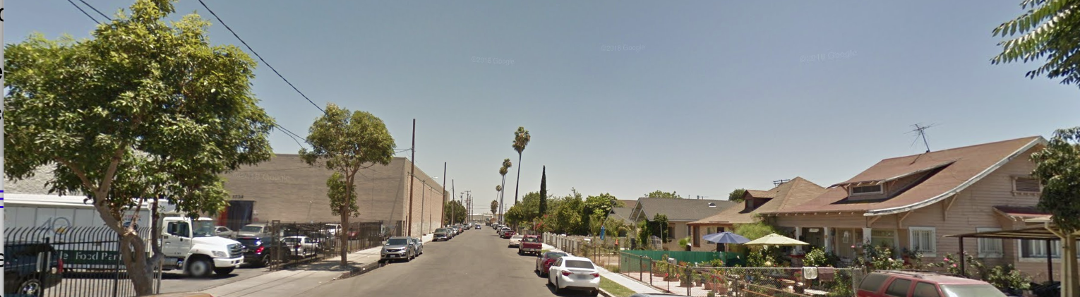 I got to know the community through a South Central heavy metal band I used to perform with, called Sector. The drummer lived on 43rd Street near Compton Avenue. The community reminds me a lot of where I grew up in Northeast LA. Homies work on their cars together. Little kids frolic in their front yards until sundown and then some. Street vendors stroll the block. Dozens of small family iglesias all project their versions of the gospel upon the street scene outside. The East Side of South Central has even retained different monikers for its different sub-sections. The northern part of the district is known as the "Low Bottoms," because of the smaller numbered streets that run through the area (e.g. 20th Street and 31st Street), while the southern portion along Long Beach Avenue is called "the Pueblos" after the Pueblo del Rio Housing Projects. The Central Avenue District.....South Central.....Historic South Central......the Low-Bottoms.......the Pueblos.....I love each of these names, as they illustrate the neighborhood from a variety of historical and socio-cultural standpoints. II. Residential Development Settlement and residential development in the East Side of South Central predates that of the West Side (e.g. Jefferson Park, Arlington Heights) by several decades—on some tracts, up to 40 years. This, in effect, makes the East Side of South Central the original South Central. There are some stunning examples of architecture in the East Side of South Central. Many specimens transcend the facadism of many tract homes around the City. It is astonishing more of the East Side of South Central does not have a historic protection overlay zone, aside from the recently-proposed 28th Street HPOZ. Granted, I’m not suggesting a sweeping HPOZ spanning the entirety of the neighborhood (since it is not the function of historic preservation to prevent any and all development. The fact is, there are plenty of architectural gems in the East Side of South Central that can and should be documented before development takes out many more of them. Let's check out some examples of residential and commercial architecture in the East Side of South Central. CLICK "READ MORE" BELOW
LAST STOP:
A Genealogy of the Naud Junction Neighborhood (Now Under the Terminal Annex and CA Endowment Buildings) INSIDE: LA's Early Immigrant Entrepreneurs ...and Their Erased Enclaves by Damian Gatto
Introduction A year and a half ago, I released my genealogy of the La Loma neighborhood of Chavez Ravine. My sample size was the neighborhood’s five remaining streets: Bouett, Brooks, Spruce, Aqua Pura, and Phoenix. My data sources were the United States Censuses from 1900 to 1940, historic building permits, land surveys, home titles, and grant deeds. I went lot-by-lot along the remaining La Loma streets documenting the builders and subsequent occupants of the homes until they were demolished. Media portrayals of Chavez Ravine during the era of its slow demise depicted the community as a ramshackle bunch of shanties and corrugated steel shacks. However, I knew based on my lifelong relationships with some of the uprooted (known as Los Desterados) that this was a vast misrepresentation. Indeed, I found that nearly every building in this five-street remnant of La Loma had a new construction permit attached to it. Another thing that fascinated me about communities like Chavez Ravine, Dogtown, Diamond Street (amongst many others) is how they were all selected to be razed and replaced with public (and sometimes private) improvements. In light of new documentation and testimonials, it is now no secret that these communities were perfectly healthy communities, but they simply had the misfortune of being built upon land that was too valuable for public and private use to be in the hands of working-class folk. The Naud Junction and Macy Street neighborhoods, which now lie, respectively, under the Terminal Annex and Union Station, were two of these such neighborhoods. This article focuses upon the Naud Junction Neighborhood, the Northern 8th Ward. The vast majority of homes were built before 1924 (when dozens were immolated, ostensibly to fend off the plague) or the mid-1930s (when they were eminent domained to build the the USPS Terminal Annex Building. When it comes to development and government improvement projects, it is easy to look to "blighted" areas (i.e. working class neighborhoods) and figure that they have to be improved upon. 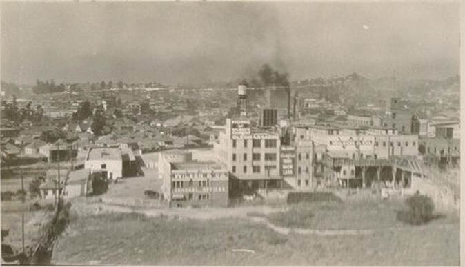
Above: The American Foundry. (Source: USC Digital Libraries)
The Naud Junction Neighborhood
From 1889 to 1909, prior to the establishment of the modern City Council representational system consisting of council districts, Los Angeles was divided into nine wards. The northern part of the Eighth Ward, which we will be strolling through today, was also called “Naud Junction” after Frenchman Edouard Naud, who built a warehouse near the modern-day William Mead Homes in 1878.
Naud Junction was marked by a signal tower built at Alameda and Ord streets in 1898. Naud Junction was also the location of the city of Los Angeles' primary boxing pavilion. USC students exchanged jabs there, and it also hosted the likes of Tommy Burns, Marvin Hart, and Abe Attel. The 8th Ward was also the site of the city's first orphanage, Institucion Caratitiva, as well as one of its most prominent infirmaries, the Los Angeles Infirmary. My motivation to do a genealogy of the Eighth Ward neighborhood was similar to Chavez Ravine. For one, I was interested in how the community was constituted demographically. I knew that the community was one of Los Angeles’ earliest melting pots. Persons of Mexican, Indigenous, Chinese, and Italian descent resided here, unable to find housing in other areas of the city due to “deed restrictions” (i.e. racial covenants) and other forms of discrimination. I was also aware of the neighborhoods role as a launching pad for numerous immigrant entrepreneurs, such as Gladding McBean & Co., the Italian-immigrant founded American Foundry, and the German immigrant-founded Kerckhoff Lumber Co. I had also heard of community institutions like the Macy Street School, designed by the famed architect A.C. Martin (of Los Angeles City Hall fame), which lasted all of 15 years before being demolished. A further motivation for performing this and other genealogies was that I wanted to further substantiate how, historically, working class communities in Los Angeles were the go-to communities that were razed in order to construct government buildings and other forms of urban redevelopment. Finally, following the illuminating results of my Chavez Ravine genealogy, I was inspired to document the daily life in the northern Eighth Ward--the community's geography, its goings-on, and its economic activity. I wanted the displaced villagers of Naud Junction to be known to future historians and Angelenos.
CLICK "READ MORE" BELOW for A Genealogy of the Eighth Ward
THE BUNGALOW THAT DOESN'T NEED AC: Some Notes on the Airplane Bungalow in Los Angeles and the United States INTRODUCTION As an enthusiast of the wood-clad architecture of the United States, there isn’t a style that is more alluring to me than the Airplane Bungalow. In the parts of the nation where they were built, Airplane Bungalows were most popular between 1910 and 1925. The style was particularly favorable in the Western, Midwestern, and Southwestern United States, where the hot seasons made the pop-up second story a cooler option for summer slumbering. The Airplane Bungalow's period of popularity coincided with the heyday of their probable parent, the Craftsman style. Airplane Bungalows share many similarities with Craftsman architecture broadly: low-pitched gabled roofs, pronounced eave overhang, exposed rafters, generous fenestration, built-in furniture, and clapboarded/shingled exteriors. Given the similarities between the two styles, it is not unreasonable to view Airplane Bungalows as an offshoot of Craftsman style; however, they could be viewed as vernacular or eclectic interpretations. What distinguishes Airplane bungalows, however, is the "pop-up" second story inherent to its design, widely described by historians as a cupola. These pop-ups usually consist solely of an extra pair of bedrooms. The isolated nature of this “pop-up” story, combined with the fenestration spanning contiguously around it, bears the likeness of an airplane cockpit to many who observe Airplane Bungalows. 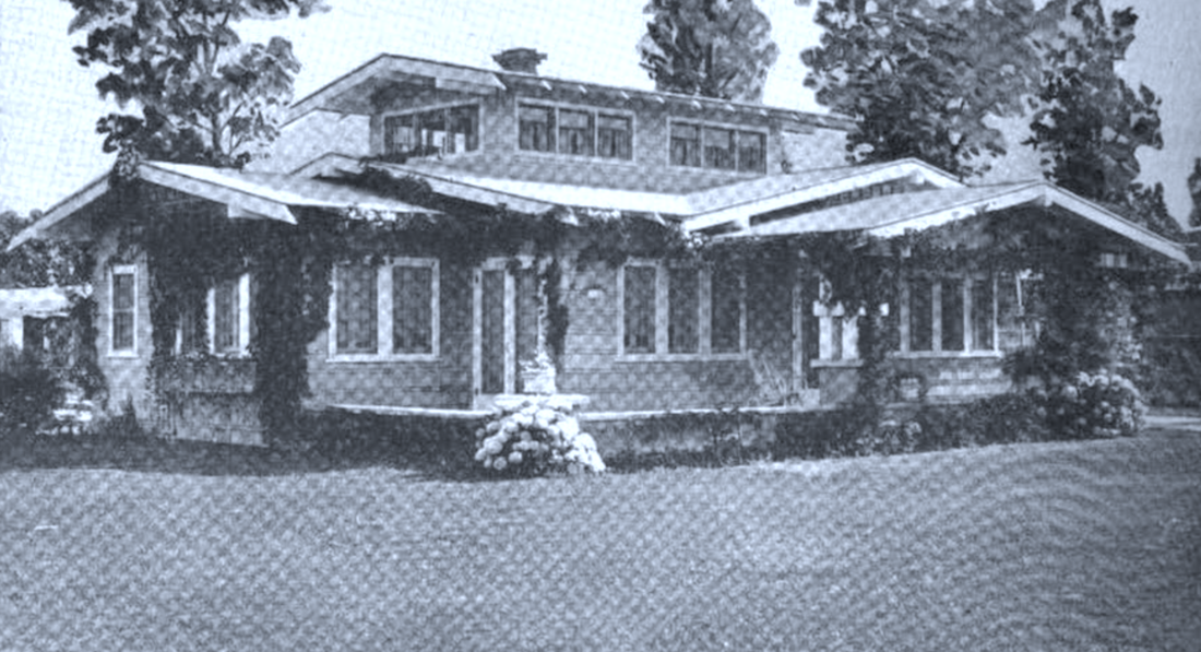 Today, we will discuss this elegant subgenre of wooden bungalow, it’s possible origins and etymology, and where to find gardens of these fine abodes in Los Angeles and elsewhere. Click "READ MORE" below
A NEW URBANIST ANGELENO'S GOLDMINE:
General Observations About Building Permits Throughout Los Angeles History by Damian Gatto
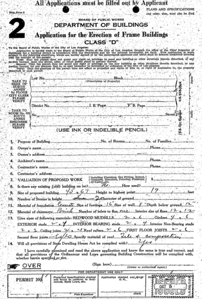
The Los Angeles Department of Building and Safety's newly streamlined process for accessing historical building permits has proven to be a truly terrific tool for historians, urbanists, and developers alike. Preservationists and historians alike use the permit system to conduct historic preservation research, sociological research, or perhaps connect some dots in their family history. Developers and administrators can use the permit system to learn about previous land uses within their project area--being that this does have impact upon their project. For a number of years, though my historic preservation and sociological research, I have extracted, certainly, thousands of permits from the LADBS archives, and their new historical permit system has made it all that much easier.
These are some general patterns I have noticed among LA building permits from 1905 to present.
Below: A mostly-blank permit that I found on an LADBS microfiche in the Norwalk building back in the old days--before the online historical records system was launched. They sure looked elegant back then. (Source: LADBS)
Click "READ MORE" below:
SOUNDS OF CRICKETS: An Analysis of The 28 LAPD Bodycam Videos From 2018 Depicting Officer-Involved Shootings and Other Uses-of-Force INTRODUCTION It has been nearly one year since the Los Angeles Police Department began routinely releasing footage from body-worn video cameras (herein, “bodycams”) depicting officers’ use-of-force (“UOF”) incidents, including officer-involved shootings (“OISs”) and In-Custody Deaths (ICDs). Bodycams are an olive branch to both the critics and the supporters of police departments. To the former, bodycams keep the police in line. To the latter, bodycams are a hedge against liability, since lawsuits almost always follow use-of-force incidents. LAPD reported 65 use-of-force incidents in 2013, 55 in 2014, 75 in 2015, 59 in 2016, 42 in 2017. They reported 39 in 2018, following the implementation of the bodycams. (Animal shootings and unintentional discharges with no injury are not counted here.) Even the Los Angeles Times has acknowledged the 30-year-low in uses of force within the Los Angeles Police Department. Even in the face of this milestone, the Police Commission voted in March 2018 to change the department’s policy regarding the release of use-of-force bodycam videos. The adopted policy prescribes that whenever any type of serious UOF is deployed, then the corresponding bodycam footage is to be released within 45 days. A simple majority vote of commissioners can extend this due date up to 28 days. Certain high-profile cases are also exempt from this deadline. LAPD were one of the first major American police departments to fully invest in and implement body-worn video cameras. The Department had released bodycam footage prior to the commission vote; however, the footage was released sporadically, and usually only after California Public Records Act requests or subpoenas by a court. The hours of footage released through the department’s YouTube page reveals a mixture of mostly excellent police work, as well as some very poor police work, and everything in between. Indeed, the now year-old library worth of footage illustrates the unpredictable situations that officers encounter on a daily basis. It also shows how, as humans, we are quite prone to error. Like every reasonable person, I believe that police officers should be held accountable for their errors, and if they are reckless or unlawful actions, they should be punished. What I object to, however, is the way that the local and national media only report on the bodycam videos that depict officer errors. This is why I decided to review each of the 28 critical incident videos released by LAPD this year and objectively report on what is depicted by police bodycam footage, closed-circuit surveillance footage, and third-party documentation. CLICK "READ MORE" BELOW
ENTER THRU THE REAR: A History of Alleys in Los Angeles and Around the World... ...And How to Repurpose Them! by Damian Gatto 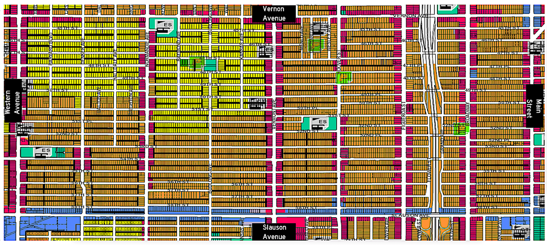 Since the early 20th century, urban alleyways in North America have conjured imagery of abandonment, clandestinity, and hazard. However, for thousands of years across human history alleys have served numerous utilitarian functions, and still do in many places around the world. Inasmuch as Los Angeles has developed a reputation as the great “unplanned city”, many districts of the city in fact have a fairly consistent gridiron layout and coherent address numbering system—complimented by an extensive network of alleys. In the United States, alleys were designed mostly for public works purposes such as utility readings, waste collection, as well as large deliveries. While alleys across the United States fell from use after the mid-20th century, so too have scholars and other thinkers mused about the possibilities for their adaptive reuse. This article will, first, provide, first, a brief history of alleyways around the world, as well as their decline and obsolescence in the United States; second, some ecological considerations; and finally, some proposed methods for the adaptive reuse of alleyways. This article will demonstrate how alleys have potential for renewed utilitarian and recreational uses. CLICK "READ MORE" BELOW
RESPONDING CODE 3: How to Listen to LAPD Radio INTRODUCTION Amateur radio operation, including listening to police and fire communications, is an American tradition. The United States is one of the few places, even in the Western Hemisphere, where it is legal to both own a digital trunking scanner AND use it to listen to telecommunications by police, fire, and other personnel. LAPD were the main pioneers in police radio technologies, as they were with other policing techniques. All of the famous radio lingo, code numbers, and other parlance all derive from LAPD and LA County Sheriffs. The technique, infrastructure, and parlance was all developed between 1924 and 1933 under the direction of LAPD Chiefs R. Lee Heath and Roy E. Steckel. Different agencies use a variety of analog and digital radio technologies across varying platforms, and thus depending on where you live, you will have to research compatibility requirements if you are going to purchase your own scanner or ham radio. If you clicked this article, you are probably wondering how you can listen to Los Angeles Police Department radio communications. Well, here it is--what you need to look for in a scanner, in-short: the scanner needs to be 1.) digital (not analog), 2.) must have P25 capability, and 3.) must also have trunking capability. In this pamphlet, we will discuss radio selection, and better, we will discuss LAPD radio protocol and parlance. I will attempt to do this as comprehensively yet concisely as I can. We will discuss how to choose a scanner, initial crime broadcasts, and subsequent communications between law enforcement and emergency operators. Finally, at the end, we will include expanded Appendices with most of the information to fill in the blanks yourself! CLICK "READ MORE" BELOW
|
Archives
December 2022
Categories
All
|
 RSS Feed
